Coordinate Transformation wizard page enables raster imagery re-projection from original (provider's) coordinate system to drawing coordinate system:
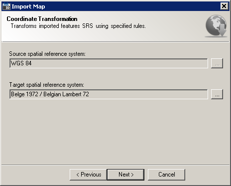
Import Map wizard Coordinate Transformation page
This wizard page provides following options:
It also provides following navigation buttons:
A spatial reference system (SRS) or coordinate reference system (CRS) is a coordinate-based local, regional or global system used to locate geographical entities. A spatial reference system defines a specific map projection, as well as transformations between different spatial reference systems. Coordinate transformation is a method that converts the spherical coordinates of the Earth representing latitude and longitude into AutoCAD drawing's Cartesian coordinate system, and accounts for the curvature of the surface of the Earth with a projection. A coordinate system is usually defined by a projection, an ellipsoid definition, a datum definition, one or more standard parallels, and a central meridian.
Target coordinate system represents default coordinate system of the current drawing and the contents therein. Most map providers serve raster imagery using WGS84 projection. Initially, you're offered default target spatial reference system, but you can change it by clicking on  button next to the target spatial reference system name:
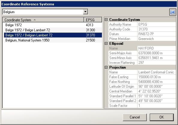
Coordinate Reference System dialog
Picking target (drawing) SRS is performed using Coordinate Reference System dialog, where you need to select region/country and one of the associated coordinate reference systems. SRS naming equals to naming provided by AutoCAD Map 3D. You can also identify target SRS by its EPSG code. But unlike Autodesk's or similar software packages, TopoPlanner uses both globally available and custom-tailored functions for coordinate transformations. One of the examples is using specialized Belgian  National Geographic Institutes's (IGN) libraries for processing coordinate transformations from and to Lambert conformal conic projection used throughout Belgium, thus making final result much precise.