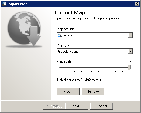
Import Map initial wizard page enables picking map vendor, type and scale:

Import Map initial wizard page
This wizard page provides following options and content management buttons:
It also provides following navigation buttons:
Supported Map Providers and Types
TopoPlanner supports following mapping providers and their specific map types:
Map Coverage |
Map Provider |
Map Type |
Global |
Google Map |
|
Google Satellite |
||
Google Terrain |
||
Google Hybrid |
||
Bing Map |
||
Bing Satellite |
||
Bing Hybrid |
||
Yahoo Map |
||
Yahoo Satellite |
||
Yahoo Hybrid |
||
OVI Map |
||
OVI Satellite |
||
OVI Terrain |
||
OVI Hybrid |
||
ArcGIS Map |
||
ArcGIS Physical |
||
ArcGIS Shaded Relief |
||
ArcGIS Terrain |
||
ArcGIS Topo |
||
MapQuest Map |
||
MapQuest Satellite |
||
MapQuest Hybrid |
||
OSM Map |
||
OSM Open Cycle Map |
||
OSM Open Cycle Map (Landscape) |
||
OSM Open Cycle Map (Transport) |
||
OSM Open Sea Map (Hybrid) |
||
Belgium |
Gewestplan (GWP) |
|
Grootschalig Referentie Bestand (GRB) |
||
Vlaamse Hydrografische Atlas (VHA) |
||
Voorlopig Referentiebestand Gewestgrens (VRBG) |
||
Orthobeeldvorming (RGB) |
||
Orthobeeldvorming (Panchromatic) |
||
Orthobeeldvorming (Infra red) |
||
Russia |
Yandex Map |
|
Yandex Satellite |
||
Yandex Labels |
||
Yandex Hybrid |
||
Spain |
SigPac Map |
Map Scale and Image Resolution
Please note that not all maps support all scale ranges as there's providers serving only large scale mapping material (e.g. map scales up to 14). Moving scale slider provides feedback of actual size of pixel on selected map scale.Try to keep scale range suitable to actual map's purpose. Downloading map data on maximum zoom scale for large area may take lots of time and may take longer and result in large image files.