The GeoView Server REST API enables querying imagery recordings by proximity. Spatial query filters feature data store by specified proximity circle, returning any image recordings contained in it. Accessing this method requires Read permissions.
Request API method URI definition:
HTTP GET http://api.geoview.be/geoservice/v1/images/<id>/proximity
Request HTTP URI parameters:
Parameter |
Description |
token |
Access token (returned by this API method). |
id |
Image identifier (returned by i.e. this API method). |
dist |
Maximum distance from specified coordinate (meters). |
srs |
Spatial reference system identifier (returned by this API method), being an |
maxcnt |
Maximum number of records to return. This parameter is optional. If omitted, returns all records within given scope. |
zoom |
Current map's zoom scale (0 = min. zoom, i.e. whole world). |
Example HTTP request URI using default GeoView Server coordinate system:
HTTP GET http://api.geoview.be/geoservice/v1/images/6e39547d-aed2-4e60-9e01-5d5c0921953a/proximity?dist=100&token=3dc718f2-ab20-4f41-86e1-72abcc1810c1
Example HTTP request URI using WGS84 coordinate system:
HTTP GET http://api.geoview.be/geoservice/v1/images/6e39547d-aed2-4e60-9e01-5d5c0921953a/proximity?dist=100&srs=4326&token=3dc718f2-ab20-4f41-86e1-72abcc1810c1
Possible resulting HTTP status codes:
Value |
Description |
200 |
API request succeeded and result(s) were returned. |
204 |
API request succeeded but query didn't produce any results. |
400 |
API request failed due to wrong parameter value(s). |
401 |
Supplied API request access token not valid. |
Response JSON structure for a single recording (please note that API method may return array of recordings):
Field |
Description |
id |
Image unique identifier. |
x |
X-ordinate value of recording in specified SRS (longitude value in WGS84). |
y |
Y-ordinate value of recording in specified SRS (latitude value in WGS84). |
created |
Image creation date string (formatted using current user's localization). |
source |
Type of raw data source used to produce image. See property constraints for more info. |
Example JSON response using default GeoView Server coordinate system:
[
{
"id":"d0efae97-51ea-4942-861f-db2dc029da84",
"x":107713.59649534024,
"y":196639.8938722061,
"created":"23/12/2017",
"source":1
},
{
...
}
]
Example JSON response using WGS84 coordinate system:
[
{
"id":"d0efae97-51ea-4942-861f-db2dc029da84",
"x":3.7653361063984652,
"y":51.078341671672753,
"created":"23/12/2017",
"source":1
},
{
...
}
]
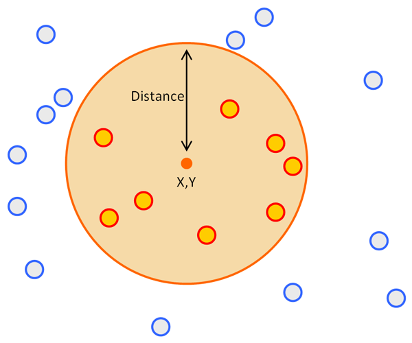
Circular range defined by X,Y coordinates of specified image and distance, and resulting selected features (red)
