The GeoView Server REST API enables querying imagery recordings by envelope. Spatial query filters feature data store by specified rectangle, returning any image recordings contained in it based on specified coordinate system and resulting data format. Accessing this method requires Read permissions.
Request API method URI definition:
HTTP GET http://api.geoview.be/geoservice/v1/images/envelope
HTTP GET http://api.geoview.be/geoservice/v1/images/envelope/<format>
Request HTTP URI parameters:
Parameter |
Description |
token |
Access token (returned by this API method). |
minx |
Minimum X-axis ordinate value (longitude value in WGS84). |
miny |
Minimum Y-axis ordinate value (latitude value in WGS84). |
maxx |
Maximum X-axis ordinate value (longitude value in WGS84). |
maxy |
Maximum Y-axis ordinate value (latitude value in WGS84). |
format |
One of the available feature data formats. This parameter is optional. If omitted, result is being returned using JSON format. |
srs |
Spatial reference system identifier (returned by this API method), being an |
maxcnt |
Maximum number of records to return. This parameter is optional. If omitted, returns all records within given scope. |
cluster |
If >0 then data clustering is used. This parameter represents total number of clusters to return. Please note that resulting IDs are empty in case of data clustering. Clustering is not available if format parameter was specified. |
filter |
If 1, then data returned is being filtered using filtering parameters returned by this API method. If 0 or omitted, no data filtering will take place and all results will be returned. Assuming filtering is on, filtering parameter values should be added to the URI parameters above. |
zoom |
Current map's zoom scale (0 = min. zoom, i.e. whole world). |
Example HTTP request URI using default GeoView Server coordinate system:
HTTP GET http://api.geoview.be/geoservice/v1/images/envelope?minx=107275.3792&miny=195092.7299&maxx=110934.7584&maxy=197065.6329&token=3dc718f2-ab20-4f41-86e1-72abcc1810c1
Example HTTP request URI using WGS84 coordinate system:
HTTP GET http://api.geoview.be/geoservice/v1/images/envelope?minx=3.75926412683421&miny=51.0644027174778&maxx=3.81125414000692&maxy=51.0823945502109&srs=4326&token=3dc718f2-ab20-4f41-86e1-72abcc1810c1
Example HTTP request URI using WGS84 coordinate system and clustering (5 clusters):
HTTP GET http://api.geoview.be/geoservice/v1/images/envelope?minx=3.75926412683421&miny=51.0644027174778&maxx=3.81125414000692&maxy=51.0823945502109&srs=4326&cluster=5&token=3dc718f2-ab20-4f41-86e1-72abcc1810c1
Example HTTP request URI using default GeoView Server coordinate system and expecting KML file as result:
HTTP GET http://api.geoview.be/geoservice/v1/images/envelope/kml?minx=107275.3792&miny=195092.7299&maxx=110934.7584&maxy=197065.6329&token=3dc718f2-ab20-4f41-86e1-72abcc1810c1
Possible resulting HTTP status codes:
Value |
Description |
200 |
API request succeeded and result(s) were returned. |
204 |
API request succeeded but query didn't produce any results. |
400 |
API request failed due to wrong parameter value(s). |
401 |
Supplied API request access token not valid. |
Response JSON structure for a single recording (please note that API method may return array of recordings):
Field |
Description |
id |
Image unique identifier. |
x |
X-ordinate value of recording in specified SRS (longitude value in WGS84). |
y |
Y-ordinate value of recording in specified SRS (latitude value in WGS84). |
Example JSON response using default GeoView Server coordinate system:
[
{
"id":"d0efae97-51ea-4942-861f-db2dc029da84",
"x":107713.59649534024,
"y":196639.8938722061
},
{
...
}
]
Example JSON response using WGS84 coordinate system:
[
{
"id":"d0efae97-51ea-4942-861f-db2dc029da84",
"x":3.7653361063984652,
"y":51.078341671672753
},
{
...
}
]
Example JSON response using WGS84 coordinate system and clustering:
[
{
"id":"",
"x":3.7653361063984652,
"y":51.078341671672753
},
{
...
}
]
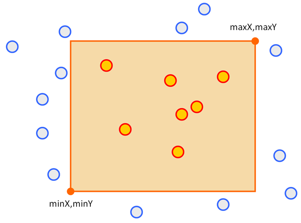
Rectangular envelope defined by minimum X,Y and maximum X,Y coordinates, and resulting selected features (red)
