Geographic coordinate system is a coordinate system that uses a three-dimensional sphere to define locations on the earth. It includes an angular unit of measure, a prime meridian, and a datum (based on an ellipsoid). Locations are referenced by longitude and latitude values. You can equate longitude values with the X axis and the latitude values with the Y axis.
Longitude and latitude are not uniform units of measure, except along the equator. Above and below the equator, the circles defining the parallels of latitude get gradually smaller until they become a single point at the North and South poles where the meridians converge and the distance represented by one degree of longitude decreases to zero.
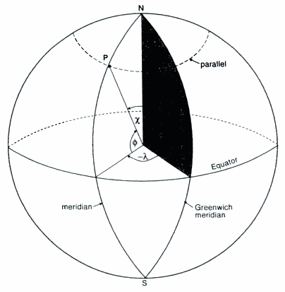
Definition sketch for geographic coordinates. The plane of the Greenwich meridian is shown cross-hatched. Meridians are great circles, parallels are small circles. Geographic coordinates of point P are defined by the angles θ (latitude) and λ (longitude). The co-latitude χ = 90 - θ.
Latitude
Latitude (θ) of point P is the angle between the normal of point P and the equatorial plane. Latitudes are positive (+) in the northern hemisphere and (-) in the southern hemisphere.
Longitude
Longitude (λ) is the angle in the equatorial plane between the Greenwich Meridian and the meridian of point P. Longitudes are positive (+) east of the Greenwich Meridian and negative (-) west of the Greenwich Meridian. Longitudes go from 0° to 180°.
Great Circle
A great circle is a line at the Earth's surface formed by a plane passing through the Earth's center (again, this definition is strictly true only for a spherical Earth). Planes passing through the Earth but not intersecting the center form small circles at the Earth's surface.
Meridian
A great circle passing through both poles, corresponding to a line of longitude. A line joining the North and South pole of the globe through some point on the surface (P) is called a meridian (although this definition does not strictly hold for an ellipsoidal shape); the longitude measures the the angle (λ) between the meridian through P and the central (prime) meridian.
Central or Prime Meridian
The line of longitude drawn through Greenwich, England, used as the origin for longitude measurements.
Parallels
Meridians are thus great circles, whereas lines of constant latitude, called parallels, are small circles, except the equator itself, which is a great circle.